
Panchayat at a Glance
Meppadi Grama Panchayat at a Glance | |
Parameter | Details |
Name | Meppadi Grama Panchayat |
Included Villages | Thrikkaipetta (Partial), Kottappadi, Vellarimala |
Block | Kalpetta |
Taluk | Vythiri |
Lok Sabha Constituency | Wayanad |
Assembly Constituency | Kalpetta |
Included Villages | Kottappadi, Vellarimala, Thrikkaipetta |
District Panchayat | Wayanad |
Area | 125.94 sq. km |
Population Density | 300 / sq. km |
Scheduled Caste (SC) Population | 3,502 |
Scheduled Caste (SC) Families | 901 |
Scheduled Tribe (ST) Population | 3,577 |
Scheduled Tribe (ST) Families | 1,038 |
Boundaries | • North: Muttil Panchayat |
• South: Malappuram District, Kozhikode District | |
• East: Muppainad Panchayat, Malappuram District | |
• West: Kozhikode District, Vythiri Panchayat, Kalpetta Municipality | |
Topography and Environmental Features
Meppadi Panchayat is situated at an altitude of more than 7000 feet above sea level. About two-thirds of the panchayat consists of mountain ranges. Vellarimala, one of the major mountain ranges in the Western Ghats, is located in this panchayat. Depending on the topography, the land can be classified into mountain ranges, high hills, steep slopes, small hillocks, plains, paddy fields, fertile foothills, and forest areas. Most of the regions comprise small hills and the valleys between them. The topography of Meppadi is highly suitable for agriculture. Regions such as Nedumpala, Poothakolli, Kadoor, Nellimunda, Chulika, Cholamala, Puthumala, Attamala, Mundakkai, Erumakolli, Chembra, Kotanad, Odathode, and Aanappara are tea plantations. Cash crops like coffee, cardamom, and black pepper are cultivated in other areas.
Red soil is found in most of the areas. It is highly acidic soil. Apart from this, rocks, black soil, sandy soil, and clay are also found. Granite rocks, white sandy soil, quartz (white stones), and clay form the mineral wealth here. Rare species of flora, unique to the world, are found in Manikunnu Hill, which is part of the Western Ghats mountain range. Similarly, rare species of plants can also be seen in the Chembra hills and surrounding areas.
Regions like Puthurvayal, Manivayal, Palavayal, Chembotharavayal, Kottatharavayal, Churakunivayal, Angadivayal, Kuzhivayal, Trikkaipetta Edathil Vayal, Cheppottuvayal, Manalothuvayal, Parakkamvayal, and Karaveedu Vayal were once the granaries (paddy hubs) of Meppadi. As paddy cultivation became unprofitable, those fields were reclaimed and converted for other crops and building constructions. Today, paddy cultivation exists only marginally in Trikkaipetta, Choorikunivayal, Chembotharavayal, and Kottatharavayal. Several regions of Meppadi Panchayat have been identified as Ecologically Sensitive Areas (ESA).
Generally, heavy rainfall is received during the months of June and July. The Thulavarsham (North-East monsoon) and the summer rains received in March, April, and May also provide relief. The highest winter chill is experienced in November, December, and January. The mist wrapping around the mountain ranges delights everyone's mind. However, climate change has been evident in recent times. The climate, which once had incessant rains, mist, and cold, is now shifting toward a dry climate. We must bring back the drizzle (Noolmazha), mist, and cold weather that are unique to Wayanad. Trees must be planted to make the environment carbon-neutral.
Meppadi Panchayat consists of two major water basins: Kabani and Chaliyar. Wards 1, 2, 3, 4, 15, 16, 17, 18, 19, 20, 21, 22, and parts of wards 5, 6, and 7 fall under the Kabani water basin. The water from the streams and rivers in these areas flows into the Kabani River and merges with the Kaveri River. The remaining parts of Wards 5, 6, 7 and the entirety of Wards 8, 9, 10, 11, 12, 13, and 14 fall under the Chaliyar water basin. The rivers in these regions—namely Elambilery River, Aranapuzha, Churalmala River, Kalladi River, and Nilambur River—flow into the Chaliyar River and empty into the Arabian Sea.
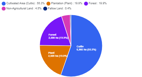
📊 Land Use Data
Sl. No. | Type | Area (in Hectares) |
|---|---|---|
1 | Total Land Area | 12,594 |
2 | Forest | 2,500 |
3 | Plantation | 2,509 |
4 | Cultivated Area | 6,966 |
5 | Fallow Land | 55 |
A) | Cultivable Fallow Land | 15 |
6 | Non-Agricultural Land | 564 |